What is an Eircode?
An Eircode is a unique postcode assigned to every address in Ireland. Unlike traditional postcode systems used in many other countries, Eircode does not simply identify a general area. Each Eircode uniquely identifies a specific property, whether that property is a house, apartment, business premises, or public building.
This property‑level precision is what makes Eircode such a powerful asset for data quality, geospatial analysis, and operational efficiency.
How an Eircode works
An Eircode consists of seven characters and is made up of two distinct components, each serving a different purpose in address identification and data processing.
1. Routing Key (first 3 characters)
The routing key identifies the broad geographic area in which an address is located. It is primarily used to support postal sorting and high‑level regional identification.
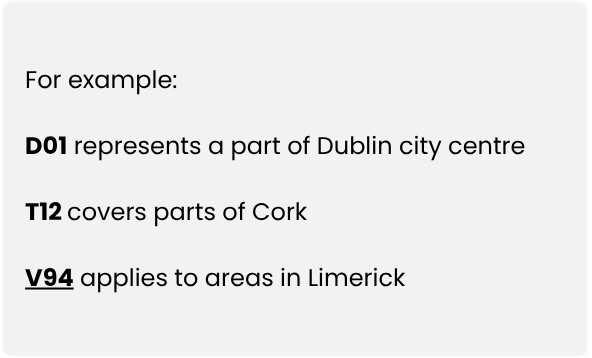.png "Blog-post-image-Address-validation-2026-(1).png")
From a data perspective, routing keys are useful for regional grouping, high‑level reporting, and spatial segmentation, but they are not sufficient for pinpointing individual properties.
2. Unique Identifier (last 4 characters)
The final four characters form the unique identifier, which distinguishes one property from every other property within the routing key.
Key characteristics:
- The identifier is randomised, not sequential
- Adjacent or neighbouring properties do not share similar codes
- The structure works equally well for urban and rural addresses
This randomness is intentional. It prevents assumptions about proximity based on code similarity and ensures that each Eircode functions purely as a unique location identifier, rather than an inferred hierarchy.
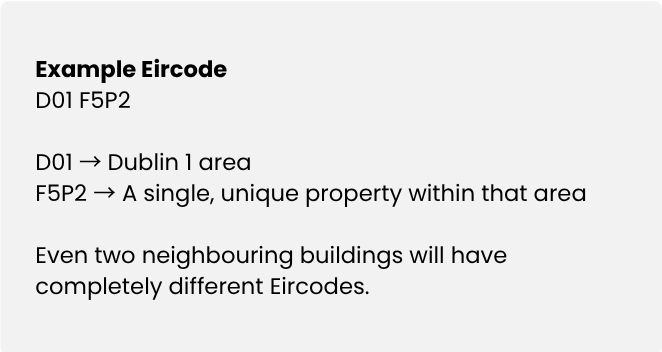.png "Blog-post-image-Address-validation-2026-(5).png")
Why Eircode is important for data‑driven organisations
Eircodes address many long‑standing challenges associated with Irish addresses, particularly in rural areas where addresses are often non‑unique, informal, or incomplete.
From a data and systems perspective, key benefits include:
More accurate deliveries and service execution
Courier networks, field service teams, and public service providers can navigate directly to the correct property, reducing reliance on local knowledge or manual clarification.
Fewer failed or delayed shipments
Ambiguous or duplicated addresses are one of the most common causes of operational failure in logistics and fulfilment systems. Eircodes significantly reduce this risk.
Support for emergency and critical services
Emergency services—including ambulance, fire, and Gardaí—can locate properties more quickly and reliably, particularly in rural or newly developed areas.
Precise geolocation and spatial analysis
Each Eircode links to accurate latitude and longitude coordinates, enabling:
- GIS mapping
- Proximity and catchment analysis
- Route optimisation
- Asset and infrastructure planning
Without an Eircode, many Irish addresses are difficult to distinguish in data systems—especially where multiple properties share the same townland or locality name.
Eircode vs traditional postcodes
Traditional postcodes were designed primarily for mail sorting by area. While effective for that purpose, they lack the precision required for modern data‑driven use cases.
Eircode extends beyond area‑level classification by enabling property‑level identification, which is critical for analytics, automation, and integration across systems.
In practice, traditional postcodes answer the question “Which area?”
Eircode answers “Which exact location?”
Common Eircode misconceptions
Despite widespread adoption, several misconceptions persist. These include:
Understanding these points is important when designing validation rules, analytics pipelines, or geospatial models.
How to find and verify an Eircode
If an Eircode is not already available, it can be sourced and verified using reliable methods such as:
- Official Eircode lookup tools
- Searches using a full, standardised address
- Cross‑checking against authoritative datasets such as GeoDirectory
For organisations managing address data at scale, storing verified Eircode’s alongside customer, asset, or service records significantly improves data quality, consistency, and interoperability across systems.
Eircode as a data asset
Eircode is more than a postcode. It is a national location identifier designed to handle the real‑world complexity of Irish addresses. When used correctly, it helps organisations:
- Deliver goods and services more efficiently
- Reduce operational costs and error rates
- Improve customer and citizen experience
- Enable accurate mapping, reporting, and analytics
Whether you are validating addresses, integrating datasets, supporting field operations, or performing location‑based analysis, Eircode plays a central role in reliable Irish address data.
Find out how you can get access to Ireland’s national address datasheet through our interactive map here.